
Home → BS5837 Planning & Development
BS5837 surveys and planning support for development projects
From initial pre-application advice through to full planning submission documentation, we support architects, developers and planning consultants at every stage of the process.
WHAT WE DO
Expert planning support at every stage
01
Trees on or adjacent to a development site can present significant constraints, and often significant opportunities. Early arboricultural input reduces planning risk and keeps your programme on track.
02
03
04
05
Pre-application advice & site visits
Early-stage site walkover and written advice identifying arboricultural constraints before your design is committed, saving time and cost.
BS5837 tree survey & constraints plan
Full mapping and assessment of all trees presenting a constraint to the site in accordance with BS5837:2012. Issued as a survey schedule (see our full survey scope), existing tree constraints plan and site notes with optional detailed shadow and canopy growth modelling. Includes liaison with the design team to reconcile as many issues as possible ahead of further work.
Arboricultural Impact Assessment (AIA)
Identification of the impacts of the proposed development on trees, assessment of the significance and recommendation of actions or mitigation where necessary. Tailored to the proposal, from annotated plan-based assessments to written report format documents. Required as part of most planning applications where trees are present on, or around, the site.
Arboricultural Method Statement (AMS)
Specification of tree protection measures needed to protect retained trees throughout the build. Based around the Tree Protection Plan (TPP), our AMS details the exact numbers of fence panels, supports and clamps, and each ground protection panel and how they all fit together, allowing up-front costing of tree protection before submission.
Post-planning support & site monitoring
Condition discharge, Non-Material Amendment (NMA) application, s73 applications, contractor briefings and periodic visits to ensure compliance with the approved AMS throughout construction.
HOW WE WORK
Predictive data-led growth modelling
The pending revision to BS5837 will ask arboriculturists to show how retained canopies will grow, not just how large they are on the day of survey. Currently there are no existing open models or longitudinal data to allow this to be undertaken in a consistent and transparent way - so we devised a simple, accessible approach using the existing body of allometric work relating stem diameter to crown radius (cross-checked against our own data), and a long-standing field rule for annual stem growth.Our position is that a projection nobody can check is worth very little in a planning context. Every rate, modifier and transition rule we use is available for scrutiny, traced to a named source, and can be applied identically to every tree and group in every survey we issue. Our full process with references, caveats and justification is available via an open licence through the adjacent link.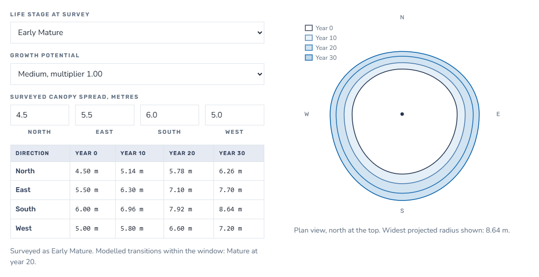
HOW WE WORK
Canopy-specific and terrain-aware tree shadow modelling
To supplement to basic method provided in BS5837, we use a GIS-based in-house tree shadow model to provide canopy specific shadows cast from the same canopy polygon that appears on the constraints plan, built from four measured cardinal spreads - so an asymmetric crown casts an asymmetric shadow.

Solar altitude and azimuth are calculated for the site's actual coordinates on the required date and time, and each shadow is followed across a LiDAR terrain surface until it meets the ground, so shadows lengthen downslope and foreshorten upslope.
A detailed and transparent interactive summary of the approach can be found via the link below.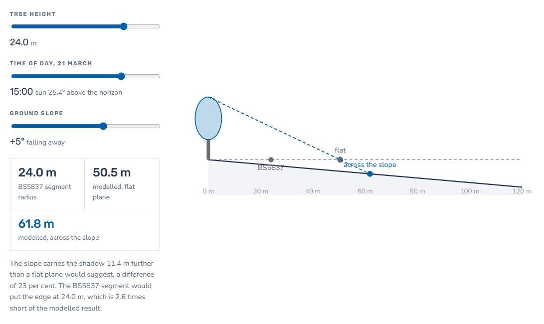
Selected projects
WHO WE WORK WITH
Planning & development · high-profile public realm
Hay Hill, Norwich - city centre public realm redevelopment
£3.2m scheme · 11 prominent high-value Cat A & B trees · structured site supervision
-
A high-profile, sensitive redevelopment built in extreme proximity to mature, high-value trees and under sustained public scrutiny. We produced a precautionary increased Root Protection Area (RPA) within our assessment to compensate for an unknown urban soil and below-ground services and supervised construction directly on site, including extensive demolition of an existing structure and water feature within 1m of a large category A Red Oak.
Result: Practical tree protection measures were implemented that allowed construction in the immediate proximity of all trees. All retained high-value trees, including the Red Oak, passed final condition inspection at handover and remain healthy.
Planning & development · multi-phase research centre
John Innes Centre - phased infrastructure schemes
£317m programme · 270+ trees & hedgerows surveyed · 5 phased AIAs to date
-
A multi-year, multi-phase research centre development where successive building and infrastructure phases needed to deliver services in extremely close proximity to mature trees in third-party ownership. We established one master AIA as a consistent baseline, then liaised with the project team to issue phase-specific AIAs and method statements as each came forward as well as being contracted to act on behalf of the appointed contractor to assist in the delivery of the scheme.
Result: Scheme amendments and mitigation that enabled the successful planning consent and hands-on implementation of recommendations with the main contractor.
Planning & development · major residential scheme
Dumpling Green, Dereham - large residential development
380 dwellings · 220+ trees, groups & hedgerows surveyed · veteran tree informed layout
-
A large residential application south of Dereham, where early identification of veteran trees fundamentally shaped the masterplan, in accordance with the NPPF. We worked with the design team to identify constraints such as modelled future growth and adjusted Root Protection Areas to reflect the disturbance from historic highway construction. We also liaised with the client's forestry team to address interim risk management arising from the survey.
Result: All irreplaceable habitats were given enough space from the adjacent proposed development. All instructed surveys and assessments delivered within agreed timeframes to ensure the target application date was met.
Planning & development · sensitive highway project
Norwich - highway widening & cycleway scheme
2 design options compared using GIS · 210+ trees, groups & hedgerows · Conservation Area
-
A time-critical highway junction and road-widening scheme within a sensitive Conservation Area, where two competing design options needed to be assessed against the same tree survey baseline without introducing errors across >200 features within the same AIA. We built a bespoke GIS-based spatial data process to cross-check tree categorisation and impact data across both options automatically, quantifying biomass and canopy loss for each using published research - giving the client robust, comparable figures to support a recommended reduction in scheme width.
Result: A rapid like-for-like comparison built on an error-checked spatial dataset allowed for an evidence based recommendation to adopt the lower-impact, reduced-width option within programme deadlines.
COMMON QUESTIONS
BS5837 planning FAQ
-
BS5837:2012 is the British Standard for managing trees in relation to design, demolition, and construction. It’s a set of guidelines that ensure trees are properly considered during development projects, protecting their health and ensuring compliance with planning requirements. A revision (BS5837:2025) has been through public consultation and is expected to introduce more prescriptive Root Protection Area (RPA) calculations and a stronger emphasis on projected canopy growth.
-
A BS5837 tree survey is needed if your site has trees within or adjacent to the boundary. This is normally required at validation stage, though it's sometimes requested later if missed. An AIA is needed once your proposed layout and the survey data show the development has the potential to conflict with retained trees.
-
An AIA is part of the design process – it evaluates how your development might affect nearby trees (and how those trees might affect your proposal). The AMS is a construction document – it shows the detail of the tree protection (barriers, ground protection, supervised excavation, etc.) required by the AIA and shows where (and when) it should be implemented.
-
Costs vary depending on the scope of the project, the number of trees, the condition and variability of the trees, site access and the specific services you need. We can price BS5837 work either as a single fee covering survey through to AMS, or stage by stage if your project timeline means decisions are being made incrementally. Many clients prefer a single instruction covering survey and AIA, with the AMS priced separately once a permission is secured and construction detail is confirmed.
-
Trees on adjoining land can still need assessing if their Root Protection Areas (RPAs) or canopies extend onto your site, or if your works could affect them. Where access to neighbouring land isn’t available, we can usually assess these trees from your boundary using laser measurement and aerial imagery, and will note any limitation this places on the assessment.
-
Yes - we routinely work alongside architects, engineers, ecologists and contractors, and the more context we have about the proposal, the more useful our recommendations will be. We're comfortable attending design team meetings, presenting tree issues and responding directly to queries from other consultants where needed.
-
Yes - we regularly attend or contribute to pre-application meetings, and can prepare informal constraints advice ahead of a formal submission to flag tree-related risk early in the design process.
-
No - they assess different things. A BS5837 AIA considers individual trees in terms of their amenity, structural condition and contribution to the landscape, and feeds into protection and retention decisions. BNG assesses habitat units across the whole site using the statutory metric. Both are usually required, and we're happy to liaise with your ecologist so the two assessments are consistent with each other rather than working from different baseline data.
-
There is no standard method within BS5837 - this means each consultant has their own approach. We start with your proposal and work out what you need while others may start with their template and make your scheme fit. Both can work, but we find our approach is more robust and leads to a smoother ride through planning.
-
Contact us by phone, email or the form below with your site details and proposed development. We’ll confirm what BS5837 work is likely required and provide a written fee proposal - there's no charge for this initial scoping conversation.
-
We’re often brought in to a project with a layout already in development. We'll review it against the tree survey data, flag any conflicts, and work with your design team to find solutions (such as amended foundation details or minor realignment) that avoid reopening the whole design.
-
We'll review the revised layout against the existing survey data and confirm whether the AIA and AMS need updating. In many cases this is a targeted amendment rather than a full reassessment, which keeps cost and delay to a minimum. We'll always tell you which it is before doing any chargeable work.
-
Our TPPs specify exact products, quantities and positions (each fence panel, clamp, support, as well as exact numbers of ground protection panels or no-dig products) so your contractor can price the protection measures accurately before submission, rather than discovering the real cost once the AMS is approved.
Want to discuss your project?
We’ll respond directly and aim to provide a quote within 3 working days.