

Home → Risk Management
Expert tree risk management for estates, landowners and public spaces
Lantra PTI certificated, QTRA registered. Practical, defensible risk assessments for estate managers, public bodies and landowners. From single trees to large-scale estate surveys.
OUR APPROACH
Proportionate, defensible and grounded in an evidence-led peer-reviewed method
We work at a range of client scales – from quiet residential gardens with a single tree to private estates with tens of thousands of trees, busy roads and public access.
The scope of our work matches these different needs, with standalone assessments at one end of the scale, through to rolling multi-layered inspection programmes within comprehensive, strategic management policies informed by remote data usage mapping and bespoke GIS visitor modelling at the other.
We use Quantified Tree Risk Assessment (QTRA) as the basis for all our risk management. QTRA is a structured method for assessing tree risk that uses numbers (instead of vague terms like “high” or “low”) to measure the likelihood of harm from tree failures, based on usage ranges derived from how long people are present within an area.
Assessment costs are generally lower with QTRA, as only areas with high enough usage are inspected and only the data from trees that need work is recorded.
01
Identifying the target
First, we assess what could be harmed. This could be users of the space (e.g., pedestrians, cyclists or drivers & passengers in vehicles) or the property within it. We assign a Target Value based on how frequently an area is used and/or what the expected occupancy is over the average year.
02
Estimating the size of the part likely to fail
When we consider partial or total tree failure, some failures are more serious than others - a small-diameter piece of deadwood is less likely to harm a pedestrian than a whole tree falling over. So, where we decide that failure is worth considering, we factor this in as the Size of Part to account for the tree’s scale, weight, and location.
03
Assessing the likelihood of failure
Next, we consider how likely the failure is to happen within the next year (taking into account the normal seasonal weather patterns and the increasing likelihood of storms and high winds as a result of climate change) and use a structured scoring system to assign it a Probability of Failure for use within the final calculation.
04
Calculating the overall risk of harm
QTRA combines the Target Value (who/what is at risk), Size of Part (how severe would the consequences be?) and the Probability of Failure (how likely is failure?) to give us a numerical Risk of Harm score, which we compare against thresholds for acceptable risk set by wider guidance from the HSE.
05
Consider the value and benefits of the tree
Wider society generally accepts the inherent risks associated with natural environments and derives substantial enjoyment and benefits from them; indeed, societal concern tends to increase when trees are lost, not when they are retained. We factor the value and benefits trees provide into our recommendations for action (if any).
06
Assigning a work priority
Finally, we’ll assign a work priority against criteria agreed with the client, taking into account their in-house resources and budget constraints. Where multiple trees share the same priority, the numerical output of QTRA lets us rank each risk so that the greatest hazard is addressed first (see our full survey terms).
We don’t do contracting - so we only specify the work that meets your needs.
Where trees do need work, our detailed tree work specifications are fully compliant with BS3998:2010, ecologically aware and the minimum intervention needed to fulfil our client’s duty of care. All pruning is wounding, so less work is good for trees, the wider environment and our client’s budget.
We collaborate with our clients to set their work priority scheduling and re-inspection approaches, and we strive to be achievable rather than setting arbitrary and unlikely timescales.
We don’t set our clients up to fail with more work than they can cope with and a deadline they can’t meet.
STRATEGIC RISK MANAGEMENT
We write robust, comprehensive tree risk management policies that balance risks with benefits
Where clients manage a significant tree stock or manage trees exposed to busy areas, we can create a site-wide policy that defines how and when the client will act in accordance with their duty of care.
This provides clarity for those involved, creates an auditable system and a defensible justification for management action in the event of a tree incident.
TREE RISK MANAGEMENT POLICY FRAMEWORK
Our policies consist of three stages: a definitive usage map collating occupancy across the site into zones, a written document defining tree benefits, responsibilities and the actions that will (and won’t) be taken to manage tree risk within those zones and when, and a rolling programme of inspections in accordance with those pre-agreed criteria.
USAGE ZONE MAPPING
Site meeting to understand footfall, seasonal patterns and land use - we see the site in person, not from aerial images. Collation of relevant remote data (e.g., Department for Transport traffic counts, LiDAR vegetation heights, PROWs etc). Preparation of GIS map benchmarked against QTRA target values. Client provides feedback and confirms usage is correct before proceeding.
WRITTEN POLICY
Comprehensive policy including (but not limited to) site-specific tree benefits, relevant guidance review, client aims, description & justification of the zoning plan, specific approach and intervals for tree inspection, extreme weather effects and contingencies, monitoring and review periods.
01
02
03
QTRA INSPECTIONS
Specific inspections of trees with the potential to affect the defined zones are undertaken on the interval defined and justified within the main policy. Works are assessed against the agreed criteria with works beyond a certain threshold of harm either optional where resources allow or otherwise recorded as not outweighing the benefits the tree (or part thereof) otherwise provides. Works priority schedule passed to contractors and implemented within the timeframes agreed in the main policy.
HOW WE WORK
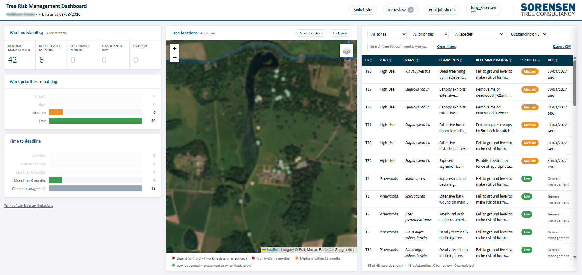
Custom client-focused dashboards track and record work schedules across any number of surveys
Our work priority dashboards allow our clients to track recommended work and check completion to ensure nothing gets missed, even with overlapping surveys, while also creating backed-up, auditable evidence of compliance.
HOW WE WORK
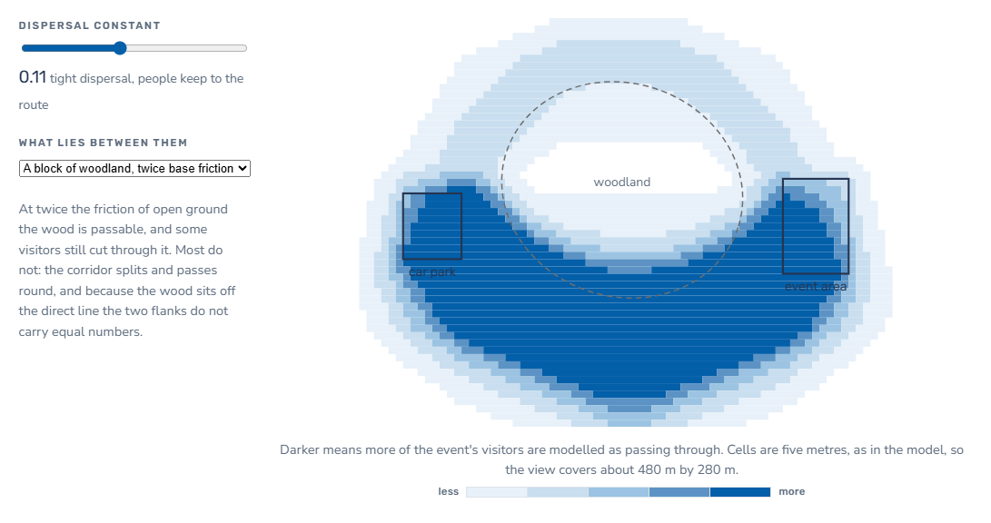
In addition to using GIS to process and display our survey data, we have developed extensive, detailed visitor modelling to provide an evidence base for decisions about usage patterns without the cost and sampling error of on-site data logging.
Using car park and ticket sale data alongside agreed, transparent assumptions about visitors based on site knowledge, our method uses a cost surface approach to make a proportional comparative heatmap of use that can be modified by points of interest and one-off event traffic.
Innovative site-specific visitor modelling approaches.
A fully explained case study, with full, transparent, reproducible calculations and interactive examples for one of our visitor models is available to view via the link below. Contact us for more details or to discuss how our approach can help with your site management.
WHO WE WORK WITH
Selected projects
TREE RISK MANAGEMENT - ESTATE POLICY
Holkham Estate - Tree Risk Management Policy
10,000+ ha estate · 1m+ visitors a year · custom GIS visitor & buffer modelling
A large coastal estate with significant public access across a historic working landscape that ranges from quiet farmland to event spaces drawing over a million visitors a year.
The policy covers:
Custom GIS visitor-pressure modelling from car park and event data
Risk-zoned usage mapping (roads, dwellings, visitors)
Beaufort-scale weather access control thresholds
Minimal-intervention principle for veteran trees
Planting prioritised above low-priority risk work
LiDAR buffer modelling
Responsibilities, review cycle & KPIs
The policy sets a clear order of priorities: trees are left alone unless they pose a genuine risk, veteran specimens are managed on a minimal-intervention basis to protect their habitat value, and planting takes precedence over low-priority risk work. Wind-related access controls follow Beaufort-scale thresholds drawn from live weather data and informed by 25-year trends, and two bespoke GIS models (mapping visitor pressure and deriving LiDAR-based event buffers) replace generic assumptions with Estate-specific evidence.
Result: A robust, bespoke, estate-wide policy, that comprehensively addresses all internal overlap with trees with clear processes and auditable targets based on site-specific evidence.
TREE RISK MANAGEMENT - LOCAL AUTHORITY MANAGED PUBLIC ROUTE
A major Sustrans route, south Norfolk - risk & condition survey
600+ trees scoped · custom risk & management survey · prioritised management plan
A multi-mile public cycling and walking route needed a proportionate risk assessment after an initial brief requiring the survey of all trees turned out to cover more than 600 individuals and groups, well beyond a useful, best value scope.
We suggested a refined, risk-focused scope, with localised comprehensive data collection at specific points of concern, then carried out a custom risk and management survey calibrated to the route's actual usage. This identified works required to mitigate unacceptable risks of harm, as well as general management works to clear street lights, and to reduce the incidence of anti-social behaviour, producing an annotated, prioritised tree plan that the client’s contracting team could act on directly.
Result: A workable, prioritised schedule of works delivered to budget, scoped down from a challenging starting brief without losing coverage of the trees that mattered.
COMMON QUESTIONS
Risk management FAQ
-
We shouldn’t think of trees as either safe or unsafe as all trees carry a degree of risk of failure. It’s important to remember that compared to many things we do in our lives, trees present a very small chance of harm. Recent work commissioned by the National Tree Safety Group (the NTSG) has benchmarked the average individual fatality risk from a falling tree to the UK public for the period 1997 – 2021 at one in 15 million per year. That’s somewhere between death by lightning and being bitten by a shark.
-
Landowners and occupiers have a legal duty of care under the Occupiers' Liability Acts 1957 and 1984 to manage tree risk on land they control. Where ownership and occupation are split (for example, a leased commercial site or a managed estate with multiple tenancies) we can help clarify where that responsibility sits and document it accordingly.
-
The NTSG (National Tree Safety Group) advises a proportionate approach with what it terms high-use areas (e.g., near roads or footpaths): regular inspections (e.g., every 1 - 3 years) and low-use areas (e.g., woodland or private gardens): less frequent inspections, unless concerns arise.
We take a variety of client and site-specific approaches that consider the realities of managing annual or multi-year budgets, or peak or off-peak periods, to ensure the best fit within the terms of that guidance.
-
Yes, in many cases - informal, regular observation by staff who know the site well is a valuable part of any risk management approach, and both the guidance and case law support this.
What matters is that your team understands the limits of their training, follows a consistent recording format, and knows when to escalate to a formal qualified inspection by a specialist. We can train your team in a basic walkover approach and set the threshold for when that escalation is needed.
-
Potentially. Landowners and occupiers have a duty of care to prevent foreseeable harm. In practice, liability findings turn heavily on whether a reasonable, documented inspection and management regime was in place.
A QTRA-based assessment and a clear inspection record are the strongest evidence you can hold that due diligence was exercised, and are often a determining factor if a claim is contested.
-
Yes, often significantly. Insurers and brokers increasingly expect evidence of a proportionate, documented tree risk management approach as part of underwriting commercial and public liability cover, and it's frequently a determining factor if a claim is made.
A QTRA-based assessment or Tree Risk Management Policy gives you a clear, justifiable course of action you can provide to your insurer or broker on request.
-
Costs vary depending on the number of trees, their location, and the level of assessment required. Using QTRA we can often rule out entire areas of trees from needing inspection due to usage of an area or the size of the trees so we often find that the final costs can be lower than other approaches.
-
We start by mapping usage across the whole estate or portfolio and applying QTRA's target range approach, which lets us rule out low-use areas from routine inspection entirely and concentrate resources where it matters most. This is usually delivered as risk-zoned GIS mapping that your team can use directly for ongoing planning.
-
Yes - as described above, our Tree Risk Management Policies set out inspection frequencies, recording formats, escalation thresholds and work prioritisation in a single governance document, so your team can manage day-to-day risk in-house with periodic professional review rather than commissioning a fresh assessment every time.
-
Yes - our survey and risk data is produced in GIS formats (GeoPackage, shapefile or CSV) compatible with most asset management and GIS platforms, so your team isn't left re-keying our findings into your own systems.
Want to discuss your site?
We’ll respond directly and aim to provide a quote within 3 working days.